ROVR Network unlocks global 3D data through distributed contributors, and when paired with GEODNET’s decentralized, centimeter-level precision layer, the stack gains the positional truth required for real-world autonomy at scale.
Scalable AI needs scalable data + accuracy. Bigger integrations coming soon🚀
رشد کنید
Rewards
قرعهکشی روزانه
100% Chance To Win With Daily Trades
قرعهکشی روزانه اسپات
Win 8,888 USDT In Grand Prizes
افزایش اعتبار خط همراه
افزایش اعتبار خط همراه بهراحتی، آنلاین و ایمن
Send
Send money globally, fast and secure
BitMart Mall
Live on crypto

ROVR Network (ROVR)
$ 0.00030 (ROVR/USD)
-3.12%
24H
ROVR Network دادههای قیمت لحظهای
قیمت امروز ROVR Network برابر با $ 0.00030 (ROVR/USD) است. با ارزش بازار برابر با $ 66,643.53 USD. حجم معاملات 24 ساعته $ 393.01 USD, تغییر قیمت 24 ساعته به میزان -3.13% و عرضه در گردش برابر با 215.29M ROVR.
ROVR Network ROVR تاریخچه قیمت USD
قیمت ROVR Network را برای امروز، 7 روز، 30 روز و 90 روز پیگیری کنید
دوره
تغییر
تغییر (%)
امروز
$ 0.0000099
-3.12%
7روزها
$ 0.00020
-39.62%
30روزها
$ 0.0028
-89.84%
90روزها
$ 0.0027
-89.44%
تجارت ROVR در سه مرحله
یک حساب کاربری رایگان ایجاد کنید، حساب خود را شارژ کنید، افزودن سپس ارز دیجیتال خود را انتخاب کنید
ROVR Network اطلاعات بازار
$ 0.00030 محدوده ۲۴ ساعته $ 0.00035
بالاترین رکورد زمانی
$ 0.0089
همیشه پایین
$ 0.00016
تغییر ۲۴ ساعته
-3.12%
حجم ۲۴ ساعت
$ 393.01
عرضه در گردش
215.29M
ROVR
مارکت کپ
$ 66,643.53
حداکثر عرضه
10.00B
ROVR
ارزش بازار کاملاً رقیقشده
$ 3.10M
معامله ROVR
کسب درآمد حتی بدون دانش مالی
Put your idle crypto to work and earn passive income through savings, staking, and more.
ROVR Network X Insight

GEODNET
Tokenomics_Expert
OnChain_Analyst
C
 130.8K @GEODNET
 صعودی
ROVR 去中心化3D数据网络受期待,短期看多。

Krypto Insider 💫 D
15.6K @KryptoInsider1 Who owns the data that powers spatial AI?
Today, much of the largest and most tightly controlled driving data is developed by a small number of major technology companies.
• Waymo.
• NVIDIA.
• Others with significant capital.
They rely on proprietary fleets, tightly calibrated sensor systems, and curated data releases. It delivers depth and consistency.
But global coverage is a different challenge.
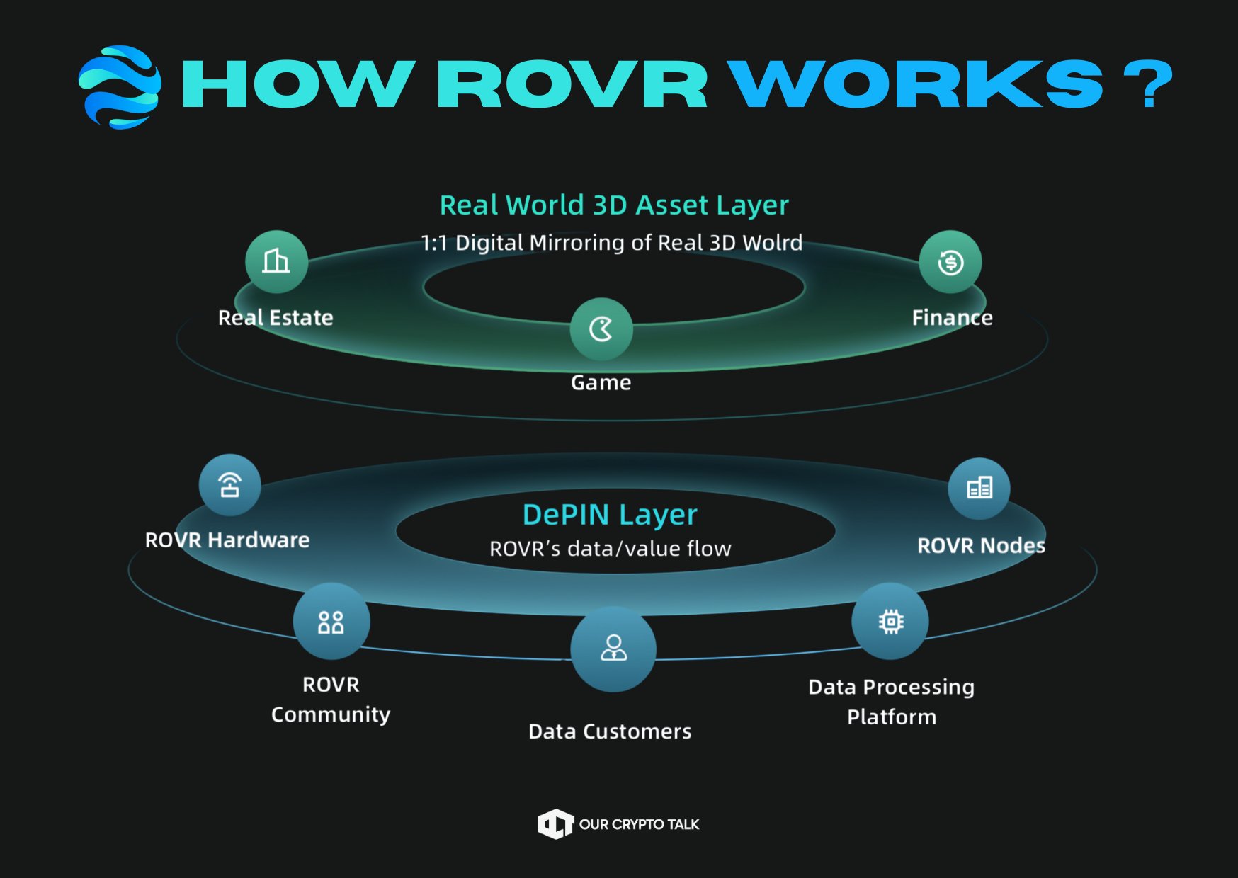
@ROVR_Network takes a structurally different approach.
Instead of relying on a vertically integrated fleet, ROVR operates a decentralized contributor network.
Participants capture high precision 3D and spatiotemporal data using standardized hardware and receive token incentives.
No single proprietary fleet. Coverage expands through distributed participation.
The tradeoff is real.
Centralized models prioritize calibration control and annotation rigor.
Distributed networks prioritize geographic breadth and expansion into underrepresented regions.
Both approaches have value.
But if spatial AI is expected
 54
54
 6
6
 3.0K
3.0K
2026-02-24 05:37
روند ROVR پس از انتشار
صعودی
ROVR 去中心化3D数据网络受期待,短期看多。

Our Crypto Talk
Media
OnChain_Analyst
C
79.7K @ourcryptotalk بسیار صعودی
ROVR continues building DePIN infrastructure during the bear market, focusing on spatial AI data, with significant progress.
RED MARKETS EXPOSE EVERYTHING.
Hype disappears but builders stay.
@ROVR_Network is one project that keeps showing up and building with progress.
Here's why and how 🧵 👇 https://t.co/El07WwJiVT

Our Crypto Talk
Media
OnChain_Analyst
C
79.7K @ourcryptotalk 1/ Crypto timelines obsess over price, ROVR is focused on something harder:
Building real-world infrastructure for Spatial AI, robotics, and autonomous systems.
That stuff doesn’t go viral and it compounds. https://t.co/6EGnuUxMKL
Our Crypto Talk
Media
OnChain_Analyst
C
79.7K @ourcryptotalk 3/ ROVR flips that model.
Instead of closed, proprietary mapping systems, they’re building a decentralized data network where anyone can contribute and earn.
Think DePIN, but for physical world intelligence. https://t.co/meyYMkLZVc
Our Crypto Talk
Media
OnChain_Analyst
C
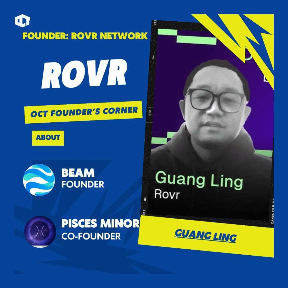
79.7K @ourcryptotalk 4/ Founded in March 202 by Guang Ling during the DePIN hype.
Even then, ROVR didn’t rush a narrative for their token launch
They shipped hardware.
They scaled contributors.
They focused on data quality.
That’s rare in this market. https://t.co/Nem6GcPWui
Our Crypto Talk
Media
OnChain_Analyst
C
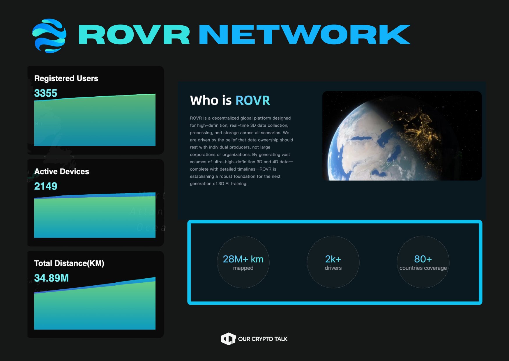
79.7K @ourcryptotalk 5/ By Mid 2025:
• 2,451 contributors
• 1,631 active devices
• 16.74 million km of roads mapped
Concept turned into execution.
Our Crypto Talk
Media
OnChain_Analyst
C
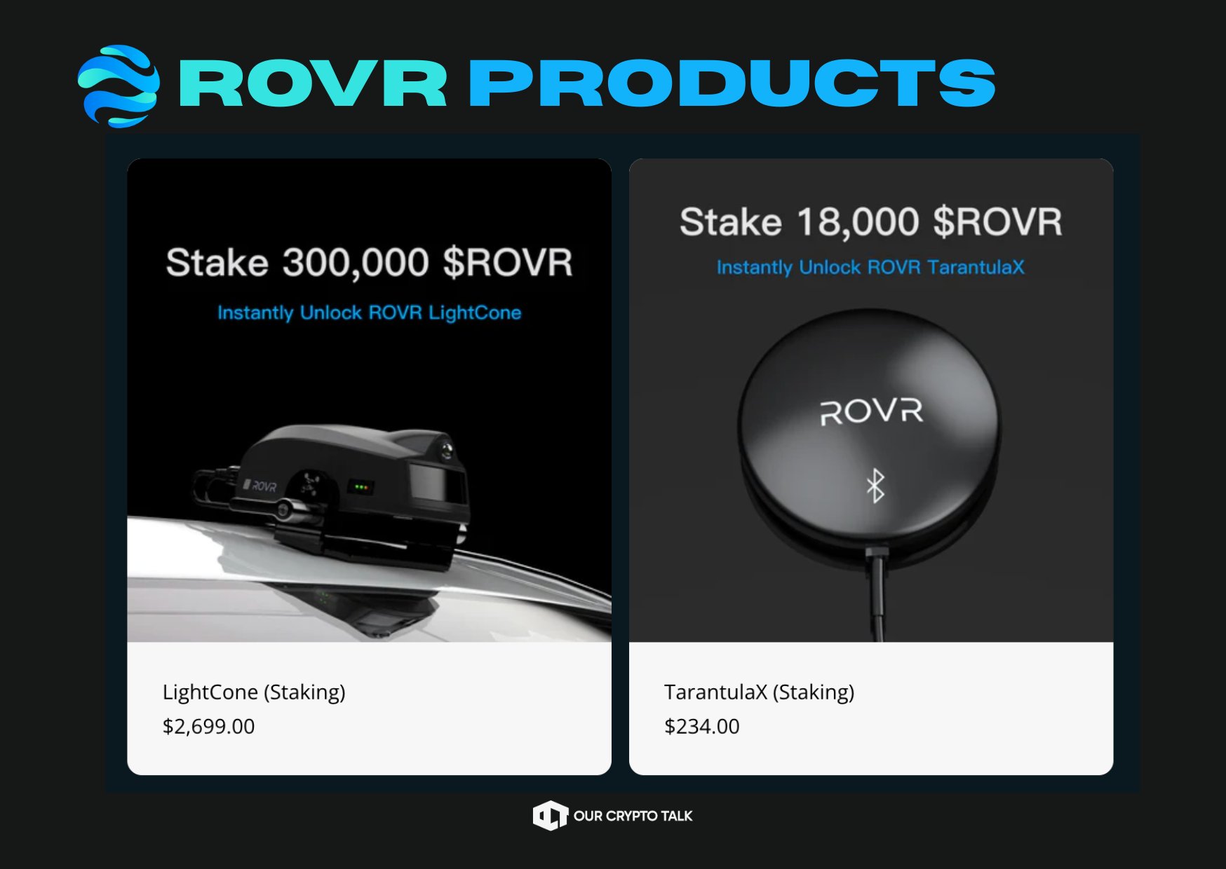
79.7K @ourcryptotalk 6/ Hardware is where ROVR gets interesting.
Their TarantulaX (TX) device delivers ~2 cm accuracy, works at highway speeds, and initially paid ~1.6 $ROVR per km.
Rewards halve yearly to reward early builders. https://t.co/QYpkXfm6HE
Our Crypto Talk
Media
OnChain_Analyst
C
79.7K @ourcryptotalk 7/ Then comes the big upgrade.
LightCone (LC):
• 126-beam solid-state LiDAR
• 1.5M points per second
• ~200m range
• Up to 16 $ROVR per km
First units shipped to early stakers in early 2026.
Our Crypto Talk
Media
OnChain_Analyst
C
79.7K @ourcryptotalk 8/ ROVR also proved quality matters.
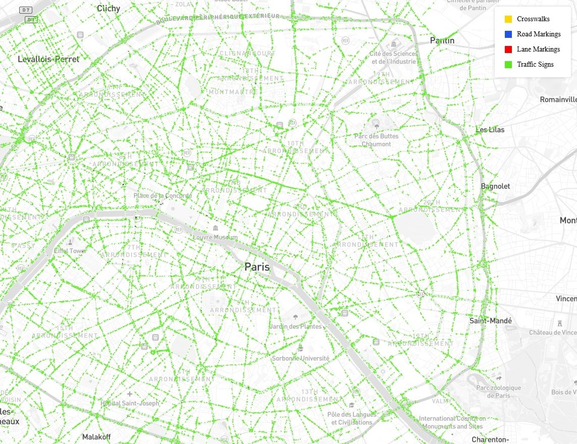
Their Paris mapping initiative covered 126 sq km with 87–92.5% accuracy for lanes, signs, and poles. https://t.co/fXM1SH58Ei
Our Crypto Talk
Media
OnChain_Analyst
C
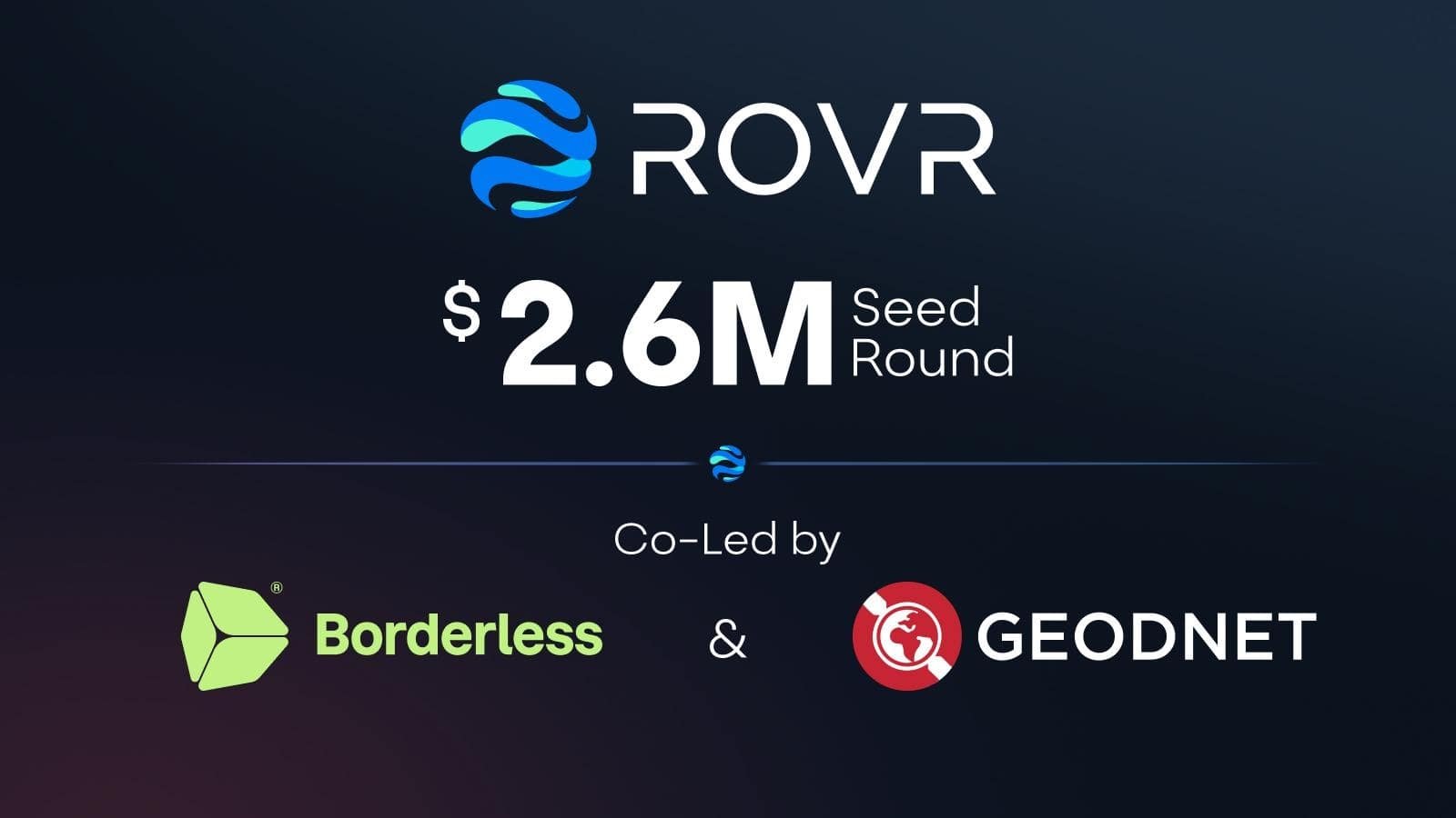
79.7K @ourcryptotalk 9/ Funding followed progress.
• $200k pre-seed (May 2024)
• $2.6M seed (April 2025)
Led by Borderless Capital + GEODNET
Token launched April 2025 with 51% supply for contributors. https://t.co/mUtoilJn1h
Our Crypto Talk
Media
OnChain_Analyst
C
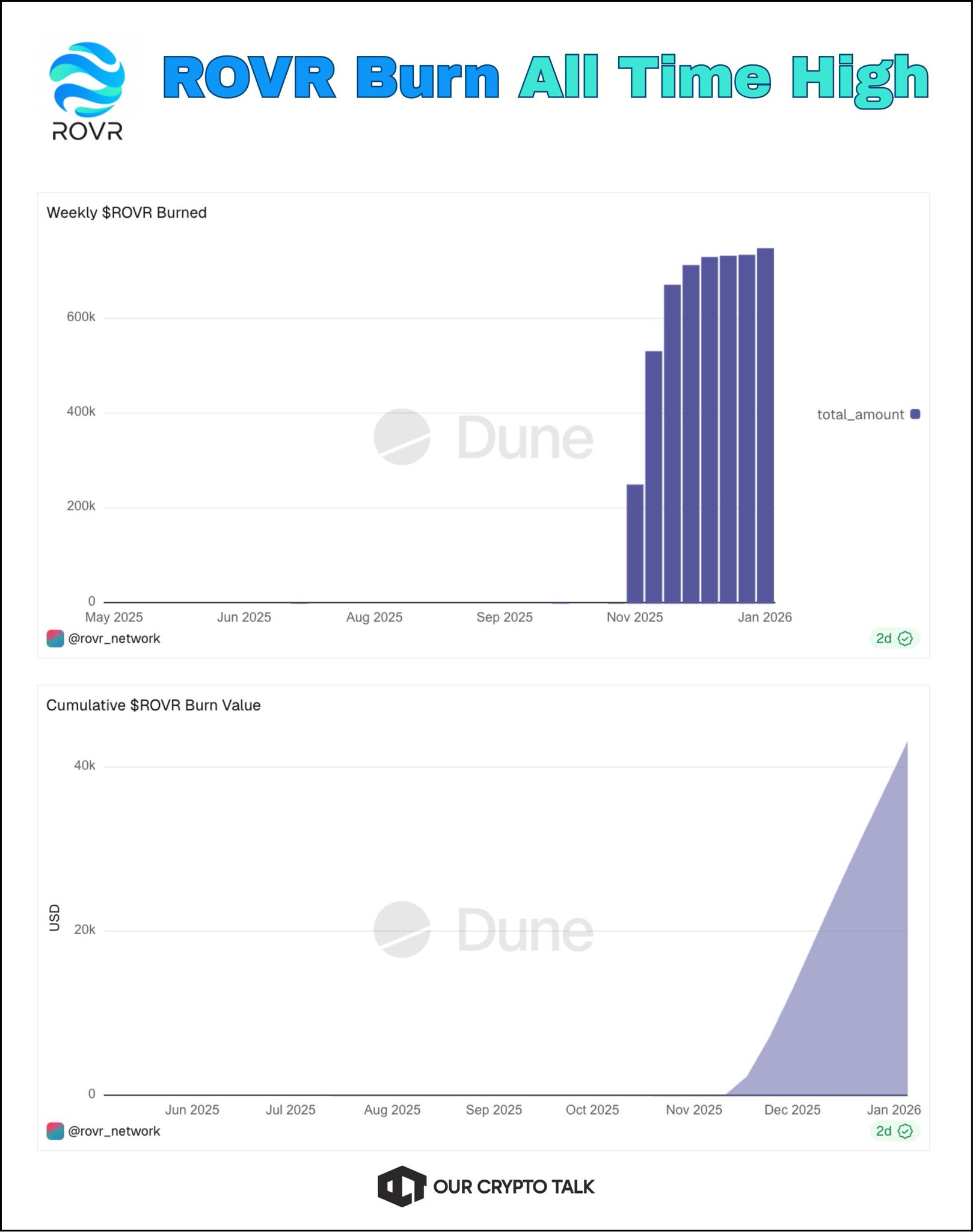
79.7K @ourcryptotalk 10/ Tokenomics aren’t just emissions.
• Tiered data quality grades
• Decay for outdated data
• 60% of data revenue burned
That’s a system designed for sustainability, not short-term pumps. https://t.co/HBasoQE1NT
Our Crypto Talk
Media
OnChain_Analyst
C
79.7K @ourcryptotalk 11/ Looking into 2026, the timing matters.
Robotics, humanoids, physical AI.
Expected 18.6% CAGR in robotics through 2033.
All of that runs on spatial data and ROVR is positioning early. https://t.co/b4MHqO0CmG

Our Crypto Talk
Media
OnChain_Analyst
C
79.7K @ourcryptotalk 12/ ROVR is building the data rails for the next AI wave, quietly and patiently.
If you’re tracking DePIN beyond narratives, this is one to watch closely 👀
- Like 👍
- Bookmark 🔖
- Repost 🔁
- Follow @ourcryptotalk
11
1
1.3K
2026-02-04 19:42
روند ROVR پس از انتشار
بسیار صعودی
ROVR continues building DePIN infrastructure during the bear market, focusing on spatial AI data, with significant progress.

OCT Gems
Influencer
Educator
B
12.5K @oct_gems بسیار صعودی
ROVR devices have started shipping, validating its staking model and real-world data collection capability.
This is a good step forward for $ROVR.
LightCone devices actually reaching early stakers means the staking model is turning into real-world data collection, not just locked tokens.
Hardware on vehicles, capturing high-precision 3D data, is what gives this network real value.
Now it’s about scale.
More devices deployed, consistent data quality, and steady demand from AI and robotics buyers will decide how far this goes.

ROVR 🌐|World Model Builder D
5.2K @ROVR_Network 🚀 ROVR Staking Update
The first batch of ROVR LightCone devices has landed and is already in the hands of our most early stakers🙌
Huge thanks to everyone who joined early — feel free to share your setup & experience here.
More staking spots are still available.
Stake $ROVR, unlock your device, and start contributing real-world data to the network.
Let’s map the world together🚀
#ROVR #DePIN #LiDAR #Staking
 7
1
383
7
1
383
2026-01-30 11:57
روند ROVR پس از انتشار
بسیار صعودی
ROVR devices have started shipping, validating its staking model and real-world data collection capability.
پیشبینی قیمت
چه زمانی برای خرید ROVR مناسب است؟ آیا اکنون باید ROVR بخرم یا بفروشم؟
از دیدگاه تجزیه و تحلیل فنی بر اساس تحلیل تکنیکال 4 ساعته ROVR، سیگنال معاملاتی نگهداری است. بر اساس تحلیل تکنیکال 1 روزه ROVR، سیگنال معاملاتی نگهداری است.

پیشبینی Beacon
پیشبینی احتمالی قیمت (24 ساعت آینده)اطلاعیه
بازارهای پیشبینی ذاتاً نوسانپذیر هستند. قیمت واقعی تراکنش ممکن است با قیمت نمایش دادهشده متفاوت باشد و پرداخت نهایی طبق قوانین تسویه پلتفرم تعیین میشود.
درباره ROVR Network
ROVR Network (ROVR) is a cryptocurrency launched in 2024and operates on the Solana platform. ROVR Network has a current supply of 9,999,998,876 with 215,292,848 in circulation. The last known price of ROVR Network is 0.00031782 USD and is down -31.19 over the last 24 hours. It is currently trading on 8 active market(s) with $948.40 traded over the last 24 hours. More information can be found at https://rovr.network/.
بیشتر بخوانید
جستجوگر بلاکچین
کاوش بیشتر
کشف BM


لیستینگ جدید

SOXLON Direxion Daily Semi Bull 3X ETF
-- 0.00%

NIOON NIO
-- 0.00%

HYGON iBoxx $ High Yield Corporate Bond ETF
-- 0.00%

AURON Aurora Innovation
-- 0.00%

IGVON iShares Expanded Tech-Software ETF
-- 0.00%

SQQQON ProShares UltraPro Short QQQ
-- 0.00%

IBITON iShares Bitcoin Trust ETF
-- 0.00%

AMCON AMC Entertainment Holdings
-- 0.00%

GRABON Grab Holdings
-- 0.00%

SNAPON Snap(Ondo)
-- 0.00%